Tag Archives: canyon

McCosker Loop Trail

28 Dec

Length: 2.6 mile loop, starting at staging area
Time: About an hour
Difficulty: Medium
Dogs: Sorry, not allowed in this part of Sibley
Calories:
400-450
Elevation Gain: 581 feet. Starts at about 750 feet and climbs to about 1250 feet.
Best Season: Avoid after heavy rains (likely muddy) or very hot days.
EMBUD Permit Required: No
To Bring Along: Binoculars, plenty of birds and views
Highlights:  Check out a brand new staging area and hike that none of your friends know about! Reach many nice viewpoints with vistas of mostly undeveloped land, including the summit of the hike, about mid way through.
Directions:  Take Canyon Road south from Moraga. When you reach Pinehurst Road, take a right. Drive about one mile past the Canyon Elementary School and look for the new Wilcox Staging Area on your right. There are roughly 10 parking spots.
Trailhead: Just walk up the gravel road to reach the trailhead.

NOTICE: The Wilcox Staging Area is currently closed for a significant creek restoration (Jan 2021).

The Wilcox Station Staging Area and McCosker Loop Trail are brand new additions to the Sibley Volcanic Preserve. If you look at the Sibley map, you’ll now see them on the far right side.

A little quick history.. The 250+ acres that have been appended to Sibley were settled by the McCosker family in the 1870s, initially as a ranch, and later as a paving and quarry operation from the 1950s-70s. The land was part of 1300 acres that were purchased by the Wilder Development (245 home sites) and then donated to East Bay Regional Parks and EBMUD in 2011. A huge thanks is due to a group of Orinda citizens called Save Open Space and assistance from the Golden Gate Audubon Society. The story is covered in a recent Lamorinda Weekly article and Audubon Society blog post.

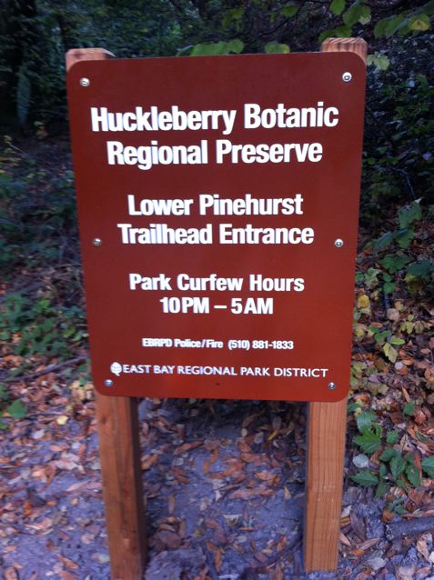
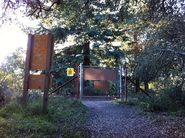
Wilcox Station Staging Area on Pinehurst Road (notice NO DOGS sign)

The Wilcox Station Staging Area, where you can park, is near the former Wilcox Station, part of the Sacramento Northern Railroad, an electric train that ran for 183 miles from Oakland all the way to Chico. Trains traveled through the one mile long “Redwood Peak Tunnel” from Shepherd Canyon on the Oakland side, before emerging in the canyon near the hairpin turn on Pinehurst Road.  A 1917 map shows the very first stop as Eastport Station (eastern portal) and the second stop as Wilcox Station.  The tiny town of Eastport still shows up in Wikipedia and on Google Maps!

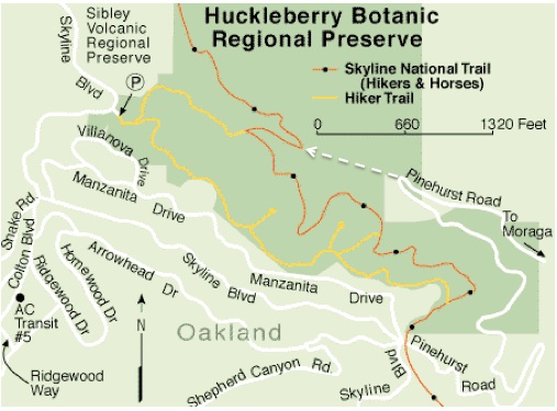
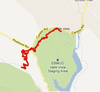
Map of the McCosker Loop Trail

To begin the hike, just head up the gravel road. After a couple tenths of a mile you’ll reach a gate, where you take a sharp right. You’ll then pass a large metal barn that now houses EBRPD equipment. Just up the hill you’ll reach the beginning of the two-mile loop trail. You can hike in either direction, but our group went right.

Just follow the trail signs!

Hiking through woodlands (with my family on the day before Christmas)

During the beginning and end of the loop you’ll pass through oak/bay laurel woodlands and then as you reach higher elevations it will be mostly open grassy hills used for cow grazing. As far as trees go, you’ll mostly see Coast live oak and California bay laurel, but may also spot Pacific madrone, Coast redwood, Giant sequoia (planted), California buckeye, and some alders by the parking lot.

Coast live oak trees

After just a short while you’ll reach a picnic table (picture below) and then a little further you’ll pass a random patch of redwood trees on the right.

Unexpected picnic spot!

While hiking we had the amazing experience of seeing direct descendants of dinosaurs, that can fly, commonly known as birds. In just an hour we spotted swallows, crows, doves, scrub jays, anna’s hummingbirds, warblers, sparrows, and a red-tailed hawk. According to an EBRP study, this new addition to Sibley has the potential to support about 300 species of birds, mammals, reptiles, and amphibians, almost half of which are birds. Common birds of Northern CA…

Trail ascending towards summit

After a surprisingly steep climb and about 30-40 minutes of hiking you’ll reach a summit of about 1250 feet. The old ranch dirt road splits into two at the top. Stay to the right, and then you’ll begin to descend. The views at the top are fantastic!

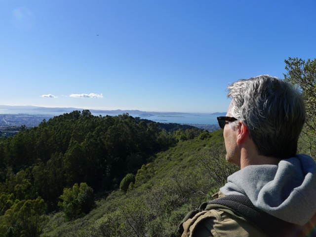
Checking out view towards Sibley’s Round Top

To the north you’ll be able to see Sibley’s Round Top in the distance. In the future, the new McCosker portion of the park will be fully connected to the rest of Sibley Volcanic Preserve, The Wilder Development, and Orinda.

Pennyroyal in full bloom

On our hike we stumbled upon a couple of wild herbs that are fun to smell: pennyroyal and wild fennel.   Pennyroyal is a non-native perennial, which is a member of the mint family and quite common on the hike.

Soon the trail will reach the junction where the loop started, and then you return past the large metal barn the same way you came.

Note: You may encounter cows on this trail. No worries. Just walk in a wide arc around them and make sure not to get between a mother and a new calf. EBMUD and the East Bay Regional Park District both lease some grassland areas for cattle grazing. This is to keep the grass height down, which lessens the fire hazard during the dry season.

McCosker area map with hiking loop shown in red

Elevation map

Claremont Canyon Lookout

14 Jan

Length: .7 miles to lookout, 1.4 miles roundtrip
Time:  20 min to lookout and 20 min back
Difficulty:   Easy-Medium
Elevation Gain: There is a little climbing on the way back.
Dogs:  Yes
EBMUD Permit:  No
Calories: ~300
Highlights:  This is a great short hike to an amazing viewpoint in the Berkeley hills that looks out over Berkeley, Oakland and the whole northern bay.  It’s a great hike to take out-of-town visitors on, and it can be done or your way to or from Oakland/Berkeley.
Directions to Trailhead:  Take Highway 24 west to Fish Ranch Road (last exit before the Caldecott tunnel).  Go right on Fish Ranch Road.  When you reach a four-way intersection take a right on Grizzly Peak Blvd.   Drive about 8/10th of a mile.  When you see logs along the left side of the road and a fire road gate on the right, park on the right side.    This trailhead is called the Scotts Peak Trailhead and is less than 10 minutes from downtown Orinda!
Special Notes:  This hike is best on a clear day with good visibility.

Nearby Grizzly Peak (1759 feet), up past the Tilden Steam Train, was named for the California grizzly bear, which inhabited the local area until sometime in the late 1800s.  The last grizzly in all of California was killed in the Sierra foothills east of Fresno in August 1922.

Beginning of Side Hill Trail

Beginning of Side Hill Trail (Grizzly Peak Blvd. in foreground)

After parking you’ll see a small trail across the street that goes over one of the big logs (see picture).  This unmarked trail is called the Side Hill Trail.   And after a couple minutes you will be on the side of a hill (get it?) with truly jaw-dropping views of San Francisco and the Golden Gate Bridge.   Down to the immediate left is Telegraph Canyon, which feeds into Claremont Canyon.   Take your time and enjoy the views!  The land and trail that you’re hiking on is part of the University of California Preserve (map).

Claremont-Sidehill

View of Side Hill Trail (San Francisco in the distance)

Claremont-Sidehill-Robert

My friend Robert enjoying the view

After 10 minutes or so on this single-track trail, you’ll emerge onto a fire road.  Remember this spot, because when you’re on your way back, it’s easy to walk right by this small trail.   Take a left going downhill.   Right away you’ll reach a four-way junction (see picture).  Going right will take you on a pleasant, flat fire road that ends at the U.C. Campus (near the Lawrence Hall of Science), and is popular with student joggers.  Going left will take you on the Claremont Trail, which descends down into Claremont Canyon.  For this hike just go straight through the intersection on what’s called the East-West Trail.   You’ll be walking on Panoramic Ridge and boy is it panoramic!

Four-way junction.  Go straight across.

Four-way junction. Go straight across.

Little side trail to the lookout on the right side.

Little side trail to the lookout on the right side.

After just a couple minutes you’ll see a little hill in front of you with a small trail on the right side (see picture).  Take that trail out to an amazing viewpoint!!  It’s a great place to bring a snack or lunch.  But the only place to sit is on the ground and there is no shade.   So prepare accordingly.   There is a little labyrinth that kids will enjoy.

Enjoying the views at the lookout!

Enjoying the views at the lookout!

After you are done enjoying the amazing view, head back exactly the way you came.

Claremont-Lookout-Map

Continuing into Claremont Canyon Regional Preserve…

If you were to continue down hill on the main East-West Trail you’d soon enter the Claremont Canyon Regional Preserve, a 208 –acre preserve nestled in the Berkeley hills behind the historic Claremont Hotel.  The trail becomes the Stonewall Panoramic Trail and runs all the way down Panoramic Ridge to a neighborhood next to the Claremont Hotel.  There are fantastic views and some pretty steep sections.   View map…

One fun idea, that I’ve done once, is to hike all the way down to the Claremont Hotel area for lunch and then hike back up to your car, parked on Grizzly Peak Blvd., after lunch.

A Little History…

Claremont Canyon, down the hill to the south of this hike, has an interesting history.  In 1858 a transcontinental telegraph line that linked the west and east coasts was strung through the canyon and in the early 1860s Pony Express riders carried mail along this route. It then became the main “highway” for horse and wagon traffic between Oakland and Contra Costa County.  The intersection of Grizzly Peak Blvd and Fish Ranch Road was an important pass and had an inn and stage stop called the Summit House located there.  Travel through the canyon declined after 1903 with the opening of the Kennedy Tunnel, which preceded today’s Caldecott Tunnel.

Huckleberry Loop from Canyon

26 Feb

Length: 3.26 miles
Time:  80 minutes
Difficulty: Easy – Medium.  Fine for kids if they can handle the length.
Elevation Gain: 590 feet
Dogs:  Not allowed
EBMUD Permit:  Not required.
Calories: 500
Highlights:  Huckleberry Botanic Regional Preserve is one of the jewels of the East Bay Park system and this hike provides quick access via Pinehurst Road versus going all the way to the main entrance on Skyline Blvd.   This hike makes a nice loop through a unique array of native plants found only in a few areas along California’s coast and rare to the East Bay.  A great hike to impress an out-of-town guest.
Directions:  Drive to Moraga and then go south on Canyon Road, which ends at Pinehurst Road.  Go right on Pinehurst Road.   You will pass through the tiny town of Canyon.   It’s fun to remember that a train used to run through this canyon.  After a little over two miles you will reach a hairpin turn with a fire road gate.  Park there.
Trailhead:   You will see a gate with “Fire Trail 41-17” on it.
Special Notes:  A self-guided nature path brochure highlighting plants that may be seen along the path is available at the entrance off of Skyline Blvd and is also available online.  I’d recommend printing at home since you’ll be entering through the backside of the park.   Text side…   Map side…

Huckleberry Entrance SignThe 240-acre Huckleberry Botanic Regional Preserve is a unique park in the East Bay Park system.  It’s not just a protected open space—it’s an ecological marvel.  The native plant community here is found nowhere else in the East Bay.  The plants originated in the distant past along the southern coast of California when the climate was more moist and tempered by cool coastal fog.  The same plants can be found on the islands off the Santa Barbara coast!

The soil in parts of the preserve is rocky and lacks nutrition for all but the hardiest chaparral species, such as Manzanita.  One of the plants to look out for is the rare and endangered Alameda Manzanita.

Huckleberry entrance gate from Pinehurst Road in Canyon

Huckleberry entrance gate from Pinehurst Road in Canyon

Park on the side of the road and begin your hike by walking past the gate and adjacent to the San Leandro Creek.  After about a quarter mile, and a short climb, you will reach a junction.  Going right leads to Sibley Volcanic Preserve and going left takes you to Huckleberry.  In either direction you will be using the Bay Area Ridge Trail or Skyline National Trail.  The Skyline National Trail runs for 32 miles through the East Bay Hills and is part of the Bay Area Ridge Trail, which makes a 550+ mile continuous trail along the ridgelines overlooking San Francisco Bay.

After veering left, hike another tenth of a mile and you will reach the “lower trail” of the Huckleberry Loop.  The lower trail winds through a mature bay forest.  Take a left.

About a half mile of hiking will bring you to a junction with a “shortcut trail” that heads up the hill through the woods.  Continue straight.  When you reach the second junction, take a right.  This is the far end of the Huckleberry Loop.   You are now on the upper trail.  The upper trail is more diverse and has most of the native plant markers.  So, if you printed out the self-guided nature path, then keep a look out for markers.

You will pass the shortcut trail again, and then reach two paths that go off to the right.  They both go out to nice sunny viewpoints and are worth the short side trips.  Two views of Mt. Diablo below…

Huckleberry View of DiabloHuckleberry-Lookout2

After about a mile on the upper trail, you will reach a junction near the entrance to the park.  Take a right and descend back down to the lower trail via a few switchbacks.  You will reach the junction where you started.

Huckleberry trail map - notice dotted line from Pinehurst Road and the loop it reaches

Huckleberry trail map – notice dotted line from Pinehurst Road and the loop it reaches

Redwood Trail

29 Jan

Length: 3.1 miles
Time: 1 hour and 15 minutes
Total Climbing: 751 feet
Difficulty: Medium
EBMUD Permit Required:  Yes
Dogs: No
Calories: 350?
Highlights: This is the fastest access to redwood trees from the Lamorinda area and crosses two undisturbed streams.  After hiking from the Valley Vista staging area (south of Moraga) back into the Canyon, you hike up through a nice redwood forest until reaching East Ridge trail in Redwood Park where you turn around.
Directions: Drive to Moraga.   Take Canyon Road until you see the Valle Vista Staging Area on your left.  Park.
Trailhead: You will see a gate and a sign in kiosk where you enter your EBMUD permit info.  Take the trail to the right.

Redwood Trail entry gate - sign in and take a right.

Redwood Trail entry gate – sign in and take a right.

Take a right on the foot path at this junction

Take a right on the foot path at this junction

Follow the dirt road to the right up a steep hill.  You will see a foot trail branch off to the right.  That is the way you want to go.   The fairly level trail winds along the side of the hill back into the canyon before dropping down into the redwood  trees.  You’ll cross Indian Creek, which is worth stopping for a minute to admire, before reaching a gate.

Cross the street to the gate on the south side of Pinehurst Road.  Now you’ll cross San Leandro Creek before winding steadily up through redwoods and ferns.  Stop for a second and realize that you’re hiking in a redwood forest within 20 minutes of your home!  We are incredibly lucky to live so near these majestic trees that can grow over 300 feet tall and live over 2000 years!  In fact, coastal redwoods are the tallest living species on Earth and the oldest recorded tree lived to more than 2200 years!

Redwood-Forest1Redwood-Forest2

This area was once a forest of ancient redwoods, but was completely logged between 1840-1860.  You may notice that the new redwood trees (only 150 years old) often grow in rough circles around where an ancient tree would have been.   That is because redwoods sprout from their stumps or roots.  When the original tree dies, the surrounding shoots may develop into mature trees in a circle around the parent. These groups are known as “fairy rings.”   Coast Redwoods like a lot of water and survive in the dry summers by capturing fog and mists that drift in from the ocean.

You should reach the top (East Ridge Trail) within 40 minutes or so.  You can extend your hike by going left or right a little ways on East Ridge trail or just turn around and head back.

The gate at the top of the hill with East Ridge Trail on the other side

The gate at the top of the hill with East Ridge Trail on the other side

Trail map from MayMyHike

Trail map from MayMyHike