Length: .7 miles to lookout, 1.4 miles roundtrip
Time: 20 min to lookout and 20 min back
Difficulty: Easy-Medium
Elevation Gain: There is a little climbing on the way back.
Dogs: Yes
EBMUD Permit: No
Calories: ~300
Highlights: This is a great short hike to an amazing viewpoint in the Berkeley hills that looks out over Berkeley, Oakland and the whole northern bay. It’s a great hike to take out-of-town visitors on, and it can be done or your way to or from Oakland/Berkeley.
Directions to Trailhead: Take Highway 24 west to Fish Ranch Road (last exit before the Caldecott tunnel). Go right on Fish Ranch Road. When you reach a four-way intersection take a right on Grizzly Peak Blvd. Drive about 8/10th of a mile. When you see logs along the left side of the road and a fire road gate on the right, park on the right side. This trailhead is called the Scotts Peak Trailhead and is less than 10 minutes from downtown Orinda!
Special Notes: This hike is best on a clear day with good visibility.
Nearby Grizzly Peak (1759 feet), up past the Tilden Steam Train, was named for the California grizzly bear, which inhabited the local area until sometime in the late 1800s. The last grizzly in all of California was killed in the Sierra foothills east of Fresno in August 1922.

Beginning of Side Hill Trail (Grizzly Peak Blvd. in foreground)
After parking you’ll see a small trail across the street that goes over one of the big logs (see picture). This unmarked trail is called the Side Hill Trail. And after a couple minutes you will be on the side of a hill (get it?) with truly jaw-dropping views of San Francisco and the Golden Gate Bridge. Down to the immediate left is Telegraph Canyon, which feeds into Claremont Canyon. Take your time and enjoy the views! The land and trail that you’re hiking on is part of the University of California Preserve (map).

View of Side Hill Trail (San Francisco in the distance)
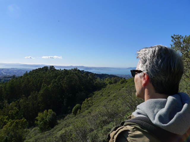
My friend Robert enjoying the view
After 10 minutes or so on this single-track trail, you’ll emerge onto a fire road. Remember this spot, because when you’re on your way back, it’s easy to walk right by this small trail. Take a left going downhill. Right away you’ll reach a four-way junction (see picture). Going right will take you on a pleasant, flat fire road that ends at the U.C. Campus (near the Lawrence Hall of Science), and is popular with student joggers. Going left will take you on the Claremont Trail, which descends down into Claremont Canyon. For this hike just go straight through the intersection on what’s called the East-West Trail. You’ll be walking on Panoramic Ridge and boy is it panoramic!

Four-way junction. Go straight across.

Little side trail to the lookout on the right side.
After just a couple minutes you’ll see a little hill in front of you with a small trail on the right side (see picture). Take that trail out to an amazing viewpoint!! It’s a great place to bring a snack or lunch. But the only place to sit is on the ground and there is no shade. So prepare accordingly. There is a little labyrinth that kids will enjoy.

Enjoying the views at the lookout!
After you are done enjoying the amazing view, head back exactly the way you came.

Continuing into Claremont Canyon Regional Preserve…
If you were to continue down hill on the main East-West Trail you’d soon enter the Claremont Canyon Regional Preserve, a 208 –acre preserve nestled in the Berkeley hills behind the historic Claremont Hotel. The trail becomes the Stonewall Panoramic Trail and runs all the way down Panoramic Ridge to a neighborhood next to the Claremont Hotel. There are fantastic views and some pretty steep sections. View map…
One fun idea, that I’ve done once, is to hike all the way down to the Claremont Hotel area for lunch and then hike back up to your car, parked on Grizzly Peak Blvd., after lunch.
A Little History…
Claremont Canyon, down the hill to the south of this hike, has an interesting history. In 1858 a transcontinental telegraph line that linked the west and east coasts was strung through the canyon and in the early 1860s Pony Express riders carried mail along this route. It then became the main “highway” for horse and wagon traffic between Oakland and Contra Costa County. The intersection of Grizzly Peak Blvd and Fish Ranch Road was an important pass and had an inn and stage stop called the Summit House located there. Travel through the canyon declined after 1903 with the opening of the Kennedy Tunnel, which preceded today’s Caldecott Tunnel.

Steve, Looks like an interesting hike. Could you start in Orinda to get up there? Alison
Yes. You can take the de Laveaga Trail, which is an EBMUD trail that begins on Camino Pablo (main drag through Orinda), just north of the Highway 24 onramp (towards Oakland) on the west side. This 2.7 mile trail winds up the hills from downtown Orinda to the Skyline Trail that runs parallel to Grizzly Peak Blvd. There are some steep sections. When you reach the Skyline Trail take a left. You’ll reach a fire road gate next to Grizzly Peak Blvd. and the start of this hike is across the street. By connecting these together you can hike from downtown Orinda over the hill and down to the Claremont Hotel area!
I’ve done this trail multiple times (typically startiong/ending at UC Berkeley, up strawberry canyon to the East Jorden Fire Trail, and then to the lookout above Grizzley Peak). Lookout is quite nice. Hike from there to Orinda is also quite nice through rolling hills, cow pastures, and, towards the bottom near Camino Pablo, a little forested area. Coming down from the lookout, you get a very very nice view of Orinda.