Length: 3.26 miles
Time: 80 minutes
Difficulty: Easy – Medium. Fine for kids if they can handle the length.
Elevation Gain: 590 feet
Dogs: Not allowed
EBMUD Permit: Not required.
Calories: 500
Highlights: Huckleberry Botanic Regional Preserve is one of the jewels of the East Bay Park system and this hike provides quick access via Pinehurst Road versus going all the way to the main entrance on Skyline Blvd. This hike makes a nice loop through a unique array of native plants found only in a few areas along California’s coast and rare to the East Bay. A great hike to impress an out-of-town guest.
Directions: Drive to Moraga and then go south on Canyon Road, which ends at Pinehurst Road. Go right on Pinehurst Road. You will pass through the tiny town of Canyon. It’s fun to remember that a train used to run through this canyon. After a little over two miles you will reach a hairpin turn with a fire road gate. Park there.
Trailhead: You will see a gate with “Fire Trail 41-17” on it.
Special Notes: A self-guided nature path brochure highlighting plants that may be seen along the path is available at the entrance off of Skyline Blvd and is also available online. I’d recommend printing at home since you’ll be entering through the backside of the park. Text side… Map side…
 The 240-acre Huckleberry Botanic Regional Preserve is a unique park in the East Bay Park system. It’s not just a protected open space—it’s an ecological marvel. The native plant community here is found nowhere else in the East Bay. The plants originated in the distant past along the southern coast of California when the climate was more moist and tempered by cool coastal fog. The same plants can be found on the islands off the Santa Barbara coast!
The soil in parts of the preserve is rocky and lacks nutrition for all but the hardiest chaparral species, such as Manzanita. One of the plants to look out for is the rare and endangered Alameda Manzanita.

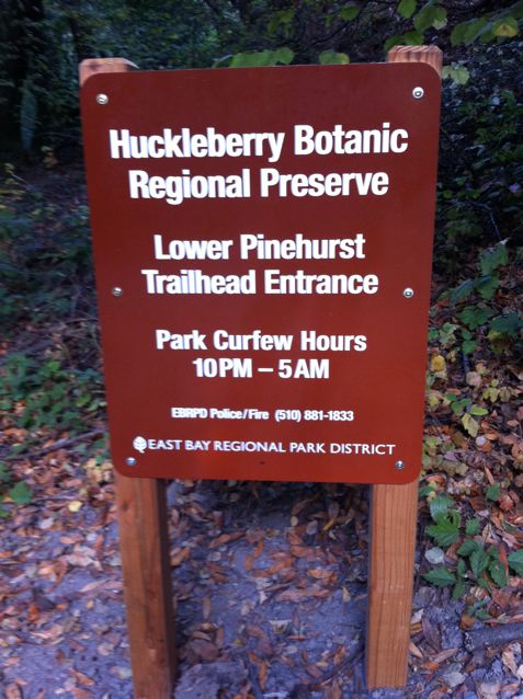
Huckleberry entrance gate from Pinehurst Road in Canyon
Park on the side of the road and begin your hike by walking past the gate and adjacent to the San Leandro Creek. After about a quarter mile, and a short climb, you will reach a junction. Going right leads to Sibley Volcanic Preserve and going left takes you to Huckleberry. In either direction you will be using the Bay Area Ridge Trail or Skyline National Trail. The Skyline National Trail runs for 32 miles through the East Bay Hills and is part of the Bay Area Ridge Trail, which makes a 550+ mile continuous trail along the ridgelines overlooking San Francisco Bay.
After veering left, hike another tenth of a mile and you will reach the “lower trail” of the Huckleberry Loop. The lower trail winds through a mature bay forest. Take a left.
About a half mile of hiking will bring you to a junction with a “shortcut trail” that heads up the hill through the woods. Continue straight. When you reach the second junction, take a right. This is the far end of the Huckleberry Loop. You are now on the upper trail. The upper trail is more diverse and has most of the native plant markers. So, if you printed out the self-guided nature path, then keep a look out for markers.
You will pass the shortcut trail again, and then reach two paths that go off to the right. They both go out to nice sunny viewpoints and are worth the short side trips. Two views of Mt. Diablo below…


After about a mile on the upper trail, you will reach a junction near the entrance to the park. Take a right and descend back down to the lower trail via a few switchbacks. You will reach the junction where you started.
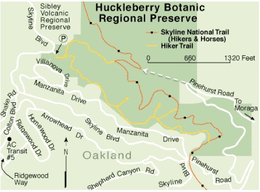
Huckleberry trail map – notice dotted line from Pinehurst Road and the loop it reaches

check it out. new area open off of pinehurst. http://www.ebparks.org/Assets/_Nav_Categories/Parks/Maps/Sibley+map.pdf
Yes, this is a great new addition! I haven’t hiked it yet, but plan to very soon. You can park at the new Wilcox Staging Area (10 parking spots) and hike the 2 mile McCosker Loop.