Archive | Uncategorized RSS feed for this section

Hunsaker Canyon Barn Walk

16 Dec

Length: 2.75 miles roundtrip from the beginning of Hunsaker Canyon Road.
Time: 45-60 minutes
Difficulty: Easy
Dogs: Yes!
Calories: Around 350
Highlights:  A very scenic stroll through Hunsaker Canyon with the first half being on a paved private road and the second half being a dirt road that used to lead to a ranch.  The land has been purchased and “land banked” by the East Bay Regional Park District but is not officially open to the public.  Enter at your own risk.
Directions:  Take Silverado Road south through Burton Valley.  Take a left on Bradbury and park where you see the green “Hunsaker Canyon Private Road” sign (see picture).
Trailhead:  Begin your hike by proceeding on Hunsaker Canyon Road by foot.
Special Notes:  Since this area has not been prepared for public use and various types of wildlife have been spotted – it is only appropriate for experienced hikers.

Hunsacker Canyon Road Sign

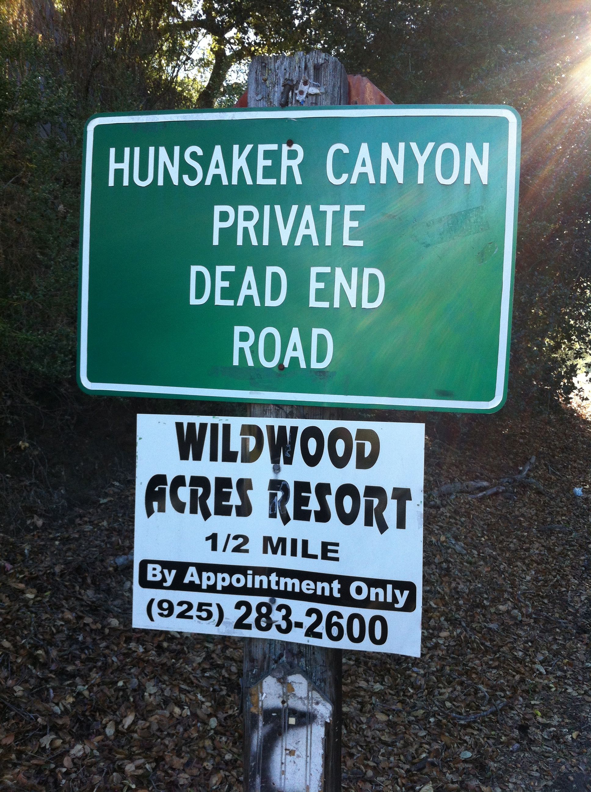
Park before this sign

Hunsaker Canyon Road is a private rural road that leads out of the south-eastern corner of Burton Valley.  It is most known as the route to Wildwood Acres Resort (for weddings and large parties), but should be known as the entry way to a great hiking area!  NOTE:  Since it is a private road it is only for residents and their guests and you aren’t supposed to park along it.  And make sure not to litter or use any cigarettes along this road.  It is an extreme fire danger area with no easy access to water.

Hike about 3/4ths of a mile down the road until you see a fire road gate on the left (see picture below).  This is the entry way to land owned by the East Bay Regional Park District.  Back in 2005, they purchased 1000 acres of land between Roosmoor, Burton Valley, and the Las Trampas Wilderness Area.  The area is protected and “land banked” but not officially open to the public.  It will expand the Las Trampas Wilderness Area to 5100 acres and protect the entire ridge line.

Entry gate to barn hike

Entry gate to barn hike

Climb over the gate to enter the open space.  A very scenic dirt road meanders through meadows and some trees, adjacent to Grizzly Creek for about 0.7 miles.  The road ends at a barn that’s no longer actively being used.  There was a huge oak tree next to the barn but it died, possibly from the drought. Anyway,  it’s a very picturesque spot!  It would be perfect for a picnic, but there is no picnic table.  There are various old supplies and fencing laying around so keep an eye on kids.  Enjoy the peaceful setting, with no signs or sounds of suburbia, and then head back.

You may run into grazing cows in the vicinity of the barn and like most East Bay parks and wilderness areas there may be mountain lions and other wildlife in the area (coyotes, boars, snakes, etc.).  But I personally haven’t seen anything except birds and cows.

This is a nice hike with a family group with varying ages and abilities because it’s manageable for just about anyone.

Barn and oak tree at the end of the dirt road.

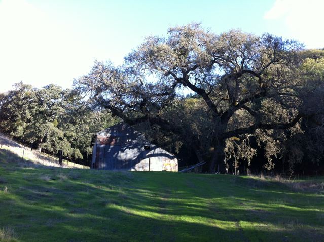
Barn and oak tree at the end of the dirt road (oak tree has since died).

Las Trampas Peak:

Right before the barn, there is a fire road that veers off to the right.  If you are really comfortable in the wilderness, you can take this fire road to Las Trampas Peak which is on the edge of the Las Trampas Regional Wilderness and 1827 feet high.  Stay left at the first junction.  Follow the fire road which has some pretty steep sections.  When you reach the ridge (Las Trampas Ridge Trail), take a right and you’ll arrive at Las Trampas Peak in another 10 minutes or so.    You will likely run into cows and maybe see other wildlife.  Best to do this hike with at least one other person.  It takes about an hour to reach the peak from the gate.

Russell Peak Loop

8 Nov

Length: 3.4 miles
Time: 1.5-2 hours
Difficulty: Medium
Dogs: Yes!
Calories: 300+
Highlights:  After a rather steep walk up a private road, you are rewarded with a great hike in the hills above Happy Valley, with outstanding views, and one of the best picnic spots around for lunch or dinner.  It takes about an hour to get to Russell Peak and about 30 minutes to get back down (shorter route).  I like to stop at Whole Foods, Diablo Foods, or Chow and pick up a picnic lunch and cold beverage and bring it along in a daypack.
Directions:  Take Happy Valley Road northwest from downtown Lafayette, until you get to Happy Valley Elementary School.  Take a right on Panorama Drive and park before the “END” sign that says “No parking beyond this point.”
Trailhead:  Head up Panorama Drive past the “END” sign.

Looking up Panorama Drive

This hike starts out with a rather steep walk up Panorama Drive, but don’t be deterred, it will be worth it.  You will reach a final house on the left and a gate across the road.  Continue hiking until you reach a post that says Mariposa Trail (see picture) and take the fire road to the left.  You can also go straight to do the loop in the opposite direction.  See map at bottom.

Mariposa means butterfly in Spanish and this trail is named after the “clouds” of butterflys that used to be found along this loop a few decades ago.    Apparently they’ve moved on.

Take a left at this sign for the Mariposa Trail

The Mariposa Trail winds west, along the side of the hill with great views out over Lafayette for about a mile or so.  When you reach a three-way junction you’ve arrived at the Russell Peak Trail.  Take a right and you’ll start climbing towards Russell Peak.

On your left you may notice the Leuschner Observatory, built in 1886 on the U.C. Berkeley Campus and moved to Lafayette in 1965.  It is located on the Russell Preserve or Russell Research Station, a 283 acre research facility of the University of California’s Center of Forestry.  Since 1961 is has provided a location for wild land and forestry research.   The University of California land is immediately to the west of the Russell Peak Trail.

Right after a really steep section you may notice a little trail on the right that goes out to a charming bench with a great view (see photo).  The bench is a memorial to a woman named Janet who apparently loved the view from this spot.  Continue until you reach another three-way junction.

This bench makes for a good pit stop on the way up…

Take a left and continue a couple tenths of a mile until you reach Russell Peak.  There is no sign for the little side trail to Russell Peak.  After climbing a pretty good hill, look for a little trail on the right that heads up to the top (see photo).   There is now one of those orange gas line markers right where the side trail goes to the peak.  If you’re on track, you’ll find a large picnic bench (see picture) after about 40 yards or so.  If you reach the Lafayette Ridge trail then you’ve gone too far.

Russell Peak is at 1357 feet and is one heck of a spot!  You can see a complete Panorama from Mt. Diablo all the way across to Round Top at Sibley and more.  Time to relax for 20 or 30 minutes and take it in.

The side trail to Russell Peak. Look for a gas line marker.

Picnic table at the top! But the brush has been cleared and it’s much more wide open now.

The view!

A cold beverage is a nice touch!

On your way back down, you’ll return to the same three-way junction, but instead of taking a right and going back the way you came, just continue straight down Mariposa Trail.  This is a shorter way back.  You’ll reach a paved road where you take a right and will pass the fire road that you took before.

The route is in the shape of a triangle.  If you spend 30 minutes at the peak, the hike will take around two hours or so.  This hike is best in spring or fall, or summer days when it’s not too hot.     Enjoy and share your feedback by posting a comment.

Russell-Peak-Map-Marked

Introduction

5 Nov

Ask most people about hiking in Lamorinda and they’ll mention the Lafayette Reservoir and Rim Trail.  But there are so many other hikes, many off the beaten path, that most people don’t know about.    And they are fantastic!  This blog will reveal them one by one to anyone interested in getting a little exercise or discovering a little wilderness right in Lamorinda!