Length: 6.6 miles
Time: 2.5 hours
Difficulty: Long hike with one steep section
Elevation Gain: 643 feet
Dogs: Allowed
EBMUD Permit: Required
Calories: 1200
Highlights: If you love the Lafayette Reservoir Rim Trail then you’ll love this hike. It’s a similar degree of difficulty, but a little longer and with fewer people. This trail leaves from the Valley Vista Staging Area, just south of Moraga, and skirts along the northern edge of Upper San Leandro Reservoir, which feels a world away from the rat race in Moraga (kidding).
Directions: Drive to Moraga. Take Canyon Road until you see the Valle Vista Staging Area on your left. Park.
Trailhead: You will see a gate and a sign-in kiosk where you enter your EBMUD permit info. Take the trail to the left.
Special Notes: Make sure to bring plenty of water!
This is the only trail next to the sprawling San Leandro Reservoir, which was completed back in 1926 by the East Bay Water Co. It receives water from the San Leandro Creek, which runs adjacent to Pinehurst Road and the small town of Canyon, traveling a total of 21.7 miles along the eastern side of the Oakland and San Leandro Hills. The creek is famous for having been the site of the first rainbow trout hatchery in the world. There are signs about the rainbow trout along Redwood Creek in Redwood Regional Park.

Beginning of the King Canyon Loop
The King Canyon Loop starts at the Valley Vista Staging Area. After you go through the gate and sign in (EBMUD permit required), head down to the left towards the reservoir on the Rocky Ridge Trail. After about a quarter mile, take the trail that veers to the left down a little hill. This will take you through a pleasant forest of monterey pines (picture below). It is native to three very limited areas located in Santa Cruz, Monterey Peninsula, and San Luis Obispo Counties. When you reach a fire road, take a right, crossing the bridge over Moraga Creek, and then passing a working ranch area with horses (picture below). After you go through a gate, you will reach a junction. The Rocky Ridge trail goes up the hill to the left. Continue straight or to the right along the reservoir. This is the beginning of the King Canyon Trail.
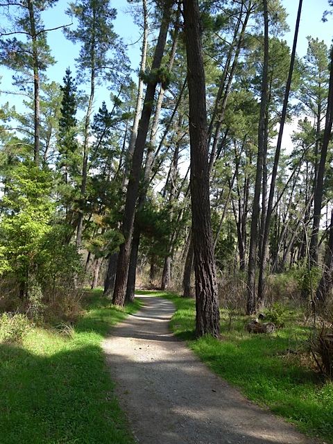

The trail winds, up and down, through a forest of California bay trees and oak trees along the northern side of the Reservoir (see picture). There are many views of the Reservoir along the way, but you’ll reach the best view after about an hour of hiking. There is a clearing with a bench and a perfect view of the Reservoir looking south (see picture). It’s worth a stop for a few minutes! This is a perfect place to have a little snack or picnic lunch. With no signs of civilization in any direction it seems a world away.

The King Canyon Trail

My favorite hiking partner admiring the view of Upper San Leandro Reservoir!
When you continue, the trail will begin to turn away from the Reservoir along an inlet. The inlet gets marshy towards the end and is a great place to spot birds. After a little ways you will reach a gate near Rancho Laguna Park. This is officially the end of the King Canyon Trail and for the rest of the loop you will be on the Rocky Ridge Trail. From here it’s 2.6 miles back to the parking lot.
Take the single-track trail to the left. When you reach a tiny creek bed, the trail appears to go right and left. Make sure to go left up the hill. Next, you will reach a fire road that goes straight up/down the hill. Take a left up the hill. This is the steepest part of the hike! Take the second right turn. The wrong turns will say “Fire Road Closed to Public.” On the next stretch you will see views of Moraga in the distance and then a great view towards the Valley Vista Staging Area once you emerge from the trees. After a steep down section, you’ll reach a junction where you take a left down the hill. Take a right at the bottom, going back to the staging area the way you came.

View of Moraga on the way back
If you don’t have time for the whole loop, you can easily hike as far as you want on the King Canyon Trail and then turn around. For instance you can turn around at 45 minutes for a 1.5 hour hike.

Hike goes counter-clockwise

The pine trees along the start of the Kings Canyon Loop Trail in the EBMUD lands – – right out of the Valle Vista Trailhead – – are actually introduced Monterey Pines. Many areas of the East Bay Hills saw the introduction of Monterey Pines around 1900.
There is an extensive stand of Knobcone Pines nearby, however, located on Moraga Ridge on EBMUD lands. But it is hard to access, as EBMUD has not granted public access to this unique botanical community centered on these Knobcone Pines. The grove runs along the ridge all the way from the ridgetop above the hamlet of Canyon, all the way down to just above Pinehurst Road. One can see the silhouettes of a few of the scraggly trees high on the ridgeline driving west from Valle Vista Trailhead. I know a hidden entrance to the Knobcone Forest, accessed from near the junction of Canyon and Pinehurst Roads.
Douglas – thanks for the correction and additional information. The post has been updated.
Friendly heads up, it’s actually King Canyon and King Canyon Loop (as opposed to King’s).
Great stuff!
Hiked this September 2023 and it was a bit of a misadventure. About 2/3 of the way around the loop, going clockwise, where the path along the reservoir crossed a steep gully with a dry-ish stream, a herd of cows had settled into the shade and was completely blocking the road. Due to the steep terrain and poison oak, my party (with children) and another party of two were unable to go around the cows. The five of us joined together and approached the cows while making noise to try to move them out of the way but one of the cows charged me and we had to retreat. Scared the hell out of the kids and made for a very long hike, especially difficult because it was so much longer than planned. I appreciate the need to maximize land use but this is not the first time we have had problematic encounters with cows on EBRPD/EBMUD trails (although this was the worst so far). The kids are threatening to refuse hiking where cows may be present (which would be very limiting as they are present on so many public lands). What do others do in situations like this?
Hi Jon, sorry to hear about the cows blocking the fire road. That is frustrating! My practice has been to make a wide arc around cows when possible or make a bit of noise to prompt them to move a bit, and haven’t experienced any “road blocks” or charging like you encountered, but maybe others have. I’m not an expert on cows. One of the main things I’ve heard is to not get between a mother and a calf. Might be worth contacting EBMUD or EBRPD to get more advice from them on how to handle. If it makes the kids more comfortable there are many great trails around Lamorinda without any cows..