Length: 4.7 miles (but you can turn around at any point)
Time: 2.5 hours
Difficulty: Challenging
Dogs: Yes
Calories: 800-1000
Highlights: The best hike leading out of the Burton Valley area. After about 15 minutes of traversing over a hill, past a house, and up a fire road, you are rewarded with an outstanding, but challenging hike that winds along the ridge between Rossmoor and Hunsaker Canyon with fantastic views on both sides. You’ll feel a world away even though you can see Rossmoor part of the time. There is a great picnic table at the end for a snack or lunch before turning around.
Directions: Drive to Burton Valley. Take Rohrer Drive off of St. Mary’s road and follow it past Burton Valley School, past Rancho Colorados Swim Club and up to Henson’s Equestrian Center (2750 Rohrer). Park across the street from the Equestrian Center.
Trailhead: You will see a small sign that says Rohrer Trail. This is the official name but I think the name should have “ridge” in it.
Special Notes: There is some poison oak on this trail, but it’s been mostly trimmed back.

The trailhead – across from Henson’s Equestrian Center
This trail will get your heart pumping right away with a few switchbacks up a steep hill between two homes. Enjoy the great views of Mt. Diablo! Drop down the other side and continue until you end up on a driveway in front of a home. Just continue past the home and you’ll see the beginning of a fire road on the opposite side. There is some cool outdoor artwork to admire.

The trail along the ridge veers off to the right before the second gate – look for post with “W10”
Going up the fire road is another noticeable climb and you’ll be thinking “I hope this is worth it!.” It will be. You’ll pass by a gate on your way up. Keep going up and over the hill. On your way down on the other side you’ll see a second gate across the fire road and maybe 15 yards before it will be a post with “W10” on it and a trail that veers off to the right. Veer right there.
It takes about 15 minutes to reach this junction and it is the beginning of the best part! This trail will wind along the ridge for 1.7 miles, taking about 45 minutes.
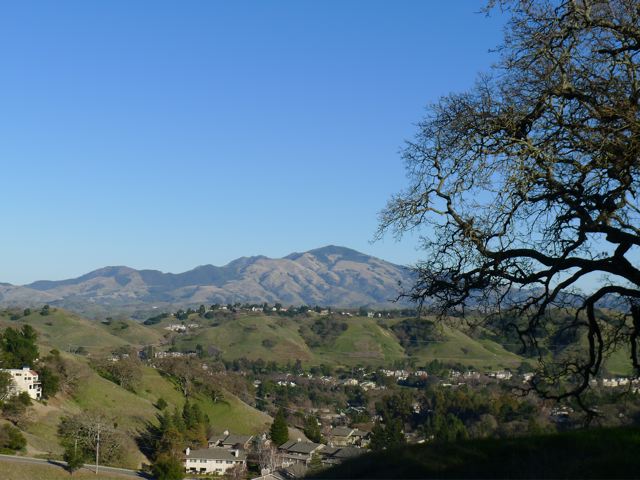
The trail is fun but a bit challenging. It goes up and down, through lots of varied plant zones, over rocks, through gates, etc. It has a little bit of everything and it’s all very scenic. As you traverse the ridge you’ll see views of Roosmoor on one side and views of Hunsaker Canyon and Las Trampas Peak on the other side.


Buddha statue
There are some special things to look for along the way. At one point on the hike you’ll go through a tiny little gully with rock walls on both sides. About 20 yards before you reach that there is a little trail off to the right with a Buddha statue – smiling in the sun (see picture).
Also worth noting is the diversity of oak trees. There are four species you can see along the way: Coast Live Oak, Valley Oak, California Black Oak, and Blue Oak. The Black and Blue Oaks are much less common and you’ll be able to spot them on the top of the ridge. Pictures of the leaves at the bottom of this post.
And in the Spring, you may notice large, mostly black butterflies. These are likely pipevine swallowtails. Picture below.

Pipevine Swallowtail Butterfly – drawn to the nectar in the sage flowers.
After about 40 minutes of hiking you’ll reach a trail intersection (“W8”) and a nice bench with a views out over Rossmoor with Mt. Diablo in the distance (see picture). This is a nice spot to take a quick break or a good turnaround point if you don’t want to go all the way to the end.


You may notice that the intersection sign says Clyde Wood Trail. This is the name given by the Rossmoor Hiking Club, who maintains the trail. Here is a link to the Rossmoor hiking map..
Continue in the same direction – one more mile to go. After going through a gate and reaching a meadow, you’ll see another post on the left with “W7” on it. Directly across is a gate. On the other side is an unofficial trail that goes down into Hunsaker Canyon, ending near an abandoned barn. This land is owned by East Bay Regional Parks and is currently “land banked” and not open to the public.

Continuing past “W7” post..
After about an hour, and roughly 2.3 miles of hiking, the trail will split into two as it gradually climbs to the top of the final hill. Going right will take you to Las Trampas Fire/Ridge Trail, which will lead you up to Las Trampas Peak if you take a right (1 – 1.5 miles?). Staying left will lead to a nice picnic table for a well-deserved rest and is the turnaround spot (see picture).

Picnic table at the end of the trail

Topographical map
Oak Tree Leaves

Black Oak leaf

Blue Oak leaf

Exactly as you described, it is a very nice hidden trail!
On Thanksgiving day 2015, I started hiking uphill from Lucas Circle next Lucas Dr, and run into the trail! What an interesting surprise! I did not know the Henson’s Equestrian Center yet!
I also saw one lady who rode her horse along the trail. Anyhow, I hiked to the Las Tramps Peak and back home in 7.5 hours.
Thanks a lot for your blog…
JW
I can’t really tell, but according to your map, it looks like this trail ends at the Las Trampas boundary. You said that you can take a fire road to Las Trampas peak. Is that the Las Trampas ridge trail? Can’t wait to check it out
Yes, the trail ends adjacent to Las Trampas Ridge Trail. It just looks like a fire road and is not marked. If you take it in the up hill direction you’ll reach Las Trampas Peak in 20-30 min. You’ll reach a gate across the fire road with a little single-track trail up to the summit on the right.
Finally got around to this hike. Couldn’t find the Buddha statue, but I did find this map from the Trails Club of Rossmoor.
Click to access Rossmoor-Trails-Map-Sept-4-2015.pdf
Thank you! I had a lot of fun on hidden this trail. I didn’t find the Buddha until the second hike, but it is still there on an overgrown turnout on the right, about three minute before the bench.
Do you take requests? Do the whole Rossmoor loop! 🙂
It’s hard to overstate how amazing this trail is. 20 minutes into the hike, and you might forget you’re in the middle of the East Bay. What a great hike! Parking was a little difficult due to horse trailers and cones taking up spaces in front of the trail, but it was easy enough to find a place off the road & out of private driveways.